Living here
Canterbury Lanes at a glance
- Starting price
- From $987,990Starting price as published by Camcos Living, checked Nov 3, 2026. Prices change without notice; confirm with the New Homes Team.
- Home types
- Townhomes
- Occupancy
- To be announced
- Sales status
- Now selling
- Builder
- Camcos Living
- City
- King · King City
- Location
- Keele St & King Rd, King City, ON
Canterbury Lanes price list and floor plans
Builders release the full price list, floor plans and deposit terms to registered buyers and brokers. Register and we send the current Canterbury Lanes package by email, or tell you when it is expected if Camcos Living has not released it yet.
About Canterbury Lanes
Quick answer: Canterbury Lanes is a pre-construction townhome community by Camcos Living at Keele Street and King Road, King City, now selling, pricing available on registration.
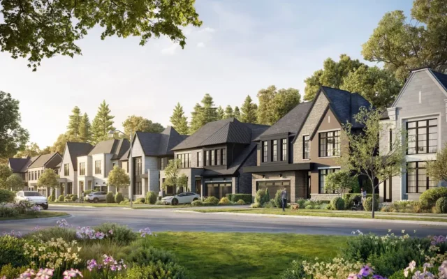
Canterbury Lanes is a townhome community by Camcos Living near Keele Street and King Road in King City. Camcos lists Canterbury Lanes as now selling, with tours available by booking, and it is one of the few new townhome options in a township better known for estate homes, which is why Canterbury Lanes King City price and floor plans are a frequent search.
King City’s village main street along Keele Street has cafes, restaurants, a grocery store, the library and community services, many within walking distance of the site. The surrounding countryside of the Oak Ridges Moraine offers golf courses, horse farms and trails including Cold Creek Conservation Area and the Oak Ridges Trail. Several well-known private schools, including Villanova College and The Country Day School, are nearby along with public schools.
King City GO station on the Barrie line puts Union Station within train commuting range, and Highway 400 is a few minutes west for drives to Vaughan, Highway 407 and Toronto. Aurora, Richmond Hill and Vaughan’s shopping and hospitals are 15 to 20 minutes away. Canterbury Lanes suits downsizers who want to stay in King, young families and commuters looking for a lower-maintenance home in a small-town setting. Register for the Canterbury Lanes price list. Renderings are artist’s concept.
Canterbury Lanes FAQs
Where is Canterbury Lanes?
Canterbury Lanes is near Keele Street and King Road in King City.
What is the starting price of Canterbury Lanes?
Camcos provides pricing on registration. Register on PreconMap for the current price list.
Who is the builder of Canterbury Lanes?
Canterbury Lanes is built by Camcos Living.
How do I get the Canterbury Lanes price list and floor plans?
Register on PreconMap for the Canterbury Lanes price list and floor plans.
Renderings are artist’s concept. Prices, availability and specifications are set by the builder and change without notice. E.&O.E.
Key highlights
- Townhomes in King City
- Keele St & King Rd
- Walk to King City shops and cafes
- Near King City GO station
- Minutes to Highway 400
- Model home tours by appointment
See nearby projects on the map
Location
Keele St & King Rd, King City, ON, King City, King. Map location is approximate. Open in Google Maps
Coming soon near Canterbury Lanes
New schools, stores, community facilities and transit near this project, with the source for each item.
Proposed or announced: not yet confirmed
Disclosure: these items are proposals, planned sites, applications, announcements or reports that have not yet been approved or funded by the city, school board or agency, or confirmed by the company. We show them early, for information only. They may change, be delayed or not go ahead, and they should not be relied on when deciding to buy. Each item shows its source and date, and is marked confirmed once an approval or funding is announced.
- Not yet confirmedKirby GO StationGO Barrie line (Metrolinx)Proposed · 7.7 km awaySource: en.wikipedia.org, Mar 31, 2022
Distances are straight-line and approximate. Confirm school boundaries with the school board and opening dates with the city or operator.
Schools, transit and amenities near Canterbury Lanes
What is close to Canterbury Lanes in King, measured in a straight line from the project location. Walking times assume streets add about 30% to the distance.
Walkability
Walkable
5 of 7 everyday needs within about a 15-minute walk: cafés and restaurants, pharmacy, park, school, bus stop.
Transit
Excellent transit
King City (GO) 900 m; nearest bus stop 50 m, 7 stops within 800 m.
Getting around
Hwy 400
Highway 400 3.1 km · Pearson Airport 29 km · Union Station 34 km (straight line).
Schools
- King City Montessori School School · private250 mabout 4 min walk
- King City Secondary School Secondary · public900 mabout 14 min walk
- King City Public School Elementary · public950 mabout 15 min walk
- Holy Name Catholic Elementary School Elementary · Catholic1.6 kmabout 25 min walk
- Villanova College Secondary · private2.2 km
- The Country Day School School · private2.7 km
School boundaries change. Confirm the assigned schools with the school board before you buy.
Transit
- King City GO900 mabout 14 min walk
- Vaughan Metropolitan Centre Subway15 km
- Keele Street / King Road bus stop50 mabout 1 min walk
- Highway 4003.1 km
Everyday life
- Coppa's Fresh Market groceries1.9 km
- King City Lions Park park350 mabout 5 min walk
- Kettle Lake Park park700 mabout 11 min walk
- Blue Heron Park park1.4 kmabout 22 min walk
- King Township Public Library - King City Branch library950 mabout 15 min walk
- Cortellucci Vaughan Hospital hospital8.8 km
Places of worship
- All Saints Anglican Church Church150 mabout 2 min walk
Colleges and universities
- Seneca College - King Campus3.0 km
Living at Canterbury Lanes: quick answers
What schools are near Canterbury Lanes?
Schools close to Canterbury Lanes include King City Montessori School (private school, about 250 m); King City Secondary School (secondary school, about 900 m); King City Public School (elementary school, about 950 m); Holy Name Catholic Elementary School (elementary Catholic school, about 1.6 km). Distances are straight-line. School attendance boundaries change, so confirm the assigned schools with the local school board before you buy.
Is Canterbury Lanes close to transit?
The nearest GO station is King City, about 900 m away, and the nearest bus stop is about 50 m away, with 7 stops within 800 m. PreconMap rates transit here as "Excellent transit".
How far is Canterbury Lanes from highways, the airport and downtown Toronto?
Highway 400 is about 3.1 km away. Toronto Pearson Airport is about 29 km and Union Station in downtown Toronto about 34 km in a straight line.
Is Canterbury Lanes walkable?
PreconMap rates it "Walkable": 5 of 7 everyday needs are within about a 15-minute walk. Nearby, the nearest supermarket is Coppa's Fresh Market, about 1.9 km away, and King City Lions Park is about 350 m away.
Which places of worship are near Canterbury Lanes?
The nearest places of worship include Church: All Saints Anglican Church (about 150 m).
Source: © OpenStreetMap contributors, checked October 2026. Walkability and transit ratings are PreconMap estimates from that data, not Walk Score® ratings. Project locations for new communities can be approximate.
Book a consultation / site visit
Pick a time to go through Canterbury Lanes by phone, video or in person.
All project details
| Project | Canterbury Lanes |
|---|---|
| Builder | Camcos Living |
| City | King |
| Neighbourhood | King City |
| Location | Keele St & King Rd, King City, ON |
| Home types | Townhomes |
| Sales status | Now selling |
| Occupancy | To be announced |